


Cedar Breaks National Monument
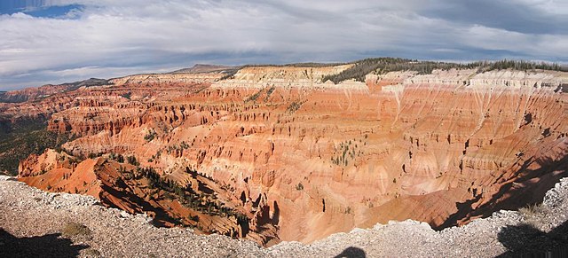
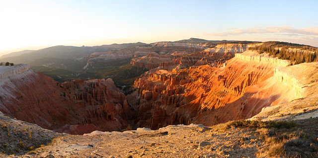
Cedar Breaks National Monument is a U.S. National Monument located in the U.S. state of Utah near Cedar City. Cedar Breaks is a natural amphitheater, stretching across 3 miles (4.8 km), with a depth of over 2,000 feet (610 m). The elevation of the rim of the amphitheater is over 10,000 feet (3,000 m) above sea level.
The rock of the amphitheater is more eroded than, but otherwise similar to, formations at nearby Bryce Canyon National Park, Red Canyon in Dixie National Forest, and select areas of Cedar Mountain (SR-14). Because of its elevation, snow often makes parts of the park inaccessible to vehicles from October through May. Its rim visitor center is open from June through October. Several hundred thousand people visit the monument annually. The monument area is the headwaters of Mammoth Creek, a tributary of the Sevier River.
Links
Images Gallery
-

-

-
 Hoodoos in Cedar Breaks
-

-
 A Larkspur wildflower near the rim of Cedar Breaks.
-

-

-

-

-

-

-

-

-

-

-

-

-

-

-

-

-

-

-


Comments
-
Cedar Breaks is a hidden gem amongst the National Parks and Monuments. The Spectra Point and Rampart Overlook trail is about 4 miles round trip. It has great views along the rim of Cedar Breaks. Be sure to bring water and snacks. The trail is well worn, but has pretty steep switchbacks in some places. It is well worth the hike, but be prepared. The elevation is over 10,000 feet, so dehydration and altitude sickness is something to be aware of.
a week ago -
Stunning and beautiful. Groomed trails in most areas make it easy to traverse the designated routes. Don't be that person wandering off the routes; environmentally sensitive wilderness and dangerous (some areas currently have no rails). The wildflowers are in full bloom in the nearby meadows and cooler temperatures during the hot summer days.
a month ago -
Again breathe taking , I would like to travel to the pond that is there, I believe its about a 1 to 2 mile hike to get there , Hopefully one day ...
a week ago -
An absolute treasure! We hiked canyon this morning and hardly saw anybody! Spectacular views without the crowds!
4 days ago -
Basically a smaller version of Bryce Canyon without the crowds. Great little and usually quiet park. Great views and hiking trails. Doesn't get many visitors even in peak season. Well worth a visit.
2 months ago -
So glad we finally got to check this off our bucket list. It was worth waiting for the seasonal road to open. The drive is amazing. Views are spectacular and easily accessible. Only a very short walk to the vistas. Note: it is very windy at that elevation, so dress for it. Also, the visitor center is not open so no facilities open. So plan accordingly. Be sure to take the time to see this sight - you won’t regret it - BEAUTIFUL!
3 months ago -
Stunning 😍 there is not much parking available in some spots, but worth the wait! Well maintained hiking trails as well. It's like a mini Bryce Canyon!
a week ago -
Went in July. It was 115 in St. George and only 77 due to elevation. Very pleasant! Great flowers. Could have spent more time there!
a month ago