


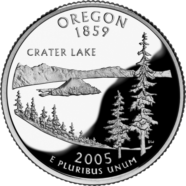


Parque nacional del Lago del Cráter (Crater Lake National Park)
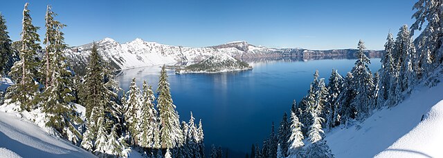
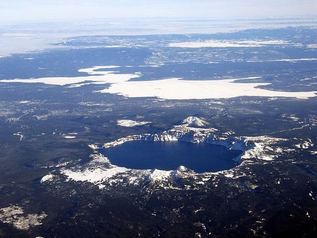
El Parque Nacional del Lago del Cráter (en inglés Crater Lake National Park) es un parque nacional de los Estados Unidos establecido en 1902 y situado en el sur del estado de Oregón. El parque, de 741,5 km², protege una zona situada en la cresta de la cordillera de las Cascadas y comprende el lago del Cráter (Crater Lake), el segundo lago más profundo de Norteamérica (589 m), sólo superado por el Gran Lago del Esclavo, en el noroeste de Canadá. El lago del Cráter ocupa el cráter de un volcán prehistórico, el monte Mazama que, según los geólogos, entró en erupción de manera violenta hace unos 7800 años. La isla Wizard, una pequeña isla junto a la orilla occidental del lago, es la cima de un volcán hoy extinto que se formó tras la destrucción del cono volcánico principal.
El lago del Cráter, de 52 km², es conocido por su intenso color azul, resultado de su gran profundidad y la claridad de sus aguas. Está rodeado por riscos de lava de entre 150 y 610 m de elevación sobre la superficie del agua. A lo largo del borde del cráter se ha construido una ruta turística para divisar el paisaje desde los automóviles. La formación y alimentación del lago se debe a la nieve y al agua de lluvia; no está alimentado ni por sumideros ni por arroyos. Las pérdidas de agua se producen por evaporación o filtraciones. Se ha introducido la trucha en el lago y se permite la pesca. En el parque están también los jardines Castle Crest Wildflower y el paisaje volcánico del desierto de Pumita.
Links
Images Gallery


Comments
-
Crater Lake might be the only National Park in Oregon but this state is filled with natural wonders. Crater Lake is the deepest lake in North America and the third deepest in the world! The water is some of the bluest water on earth. This place offers boat tours amazing hiking trails and some of the most visually stunning views in nature.
2 days ago -
What an amazing experience! This is one of the most beautiful places I have ever seen in my life! My family and I thoroughly enjoyed this trip and probably will be taking it again one day! The size of this place was just awe inspiring! The water in the lake was a gorgeous blue like I have never seen! It was awesome to be there in June and there was still snow on the ground. The wildlife was very cool, and my kids loved seeing and feeding the squirrels. We drove halfway around the lake and had to head to our next stop. I really wish we could have made it all the way around the lake, but maybe next time. Be sure to stop at the different viewpoints as each one of them has their own amazing scene just waiting for you to take in it's beauty! Trust me, if you are anywhere close to Crater Lake you will have to take a trip there. Plan on spending several hours, because if you don't you will regret it! I'm looking forward to seeing your reviews, because you will not be able to visit this place without sharing your experience!
2 weeks ago -
Just an amazing absolute wonderful place. The loop is about 33 miles and can take 2 to 3 to 4 hours depending on how many places you stop. I recommend taking the clockwise direction because it seems like most other people take the counter clockwise drive.
3 weeks ago -
Stunning view and a memorable experience. Easy to navigate through the park and lot of pull off the road shoulders to enjoy the majestic scenery. The hiking trail to Mount Scott was awesome.
3 weeks ago -
I have spent 30 days on a road trip visiting several National Parks. I can say for sure that this offered the most amazing views. Unbelievable. The watchman point has a steep hike with some rest stops. The view from up there makes the hike up worth.
3 weeks ago -
hot, smokey, crowded and still absolutely STUNNING. Was well over 100° the day we visited which is rare for the area but driving around the rim was a truly remarkable experience - can’t wait to come back and spend more time here.
a month ago -
Stunning! Lots of trails and easily accessible areas to people with limited abilities! The whole place is a geological wonder and is stunning. Only draw back was lack of restrooms through the park. We will definitely visit again
a month ago -
Place is beautiful, but from the fires it is extremely hard to see the actual lake. Right now from COVID you also must have a mask on to go into any of the buildings. They DO NOT provide free mask you have to pay pretty much double to get one at any of the stores.
a week ago