
.")


Makalu Baruns nationalpark (मकालु-बरूण राष्ट्रिय निकुञ्ज)
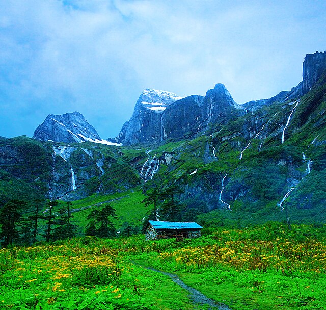
Makalu Baruns nationalpark er en nationalpark i Nepal, den ottende nationalpark, og blev etableret i 1992, som en østlig forlængelse af Sagarmatha nationalpark. Nationalparken er 1500 km2 og ligger i distrikterne Solukhumbu og Sankhuwasabha. Det er verdens eneste reservat som har en højdeforskel på mere end 8000 meter, og indeholder såvel jungle som sneklædte bjergtoppe. Nationalparken er omgivet af en bufferzone på 830 km2.Reservatet har fået sit navn fra en af områdets gletsjere, Barun-gletsjer og af det højeste bjerg. Inde i nationalparken er verdens femthøjeste bjerg, Makalu, 8463 m.o.h. og endvidere Chamlang , 7319 m.o.h., Baruntse, 7129 m.o.h. og Mera Peak, 6654 m.o.h.
Det beskyttede område er cirka 66 kilometer i øst-vest og 44 kilometer i nord-syd retning. Fra dalen ved Arun river i sydøst er højden 344-377 m.o.h. og parkområdet stiger op til Makalus top på 8462 meters højde. Nationalparken grænser mod nord mod Chomolungmas naturreservat i Tibet.Det beskyttede område udgør også en del af det beskyttede Sacred Himalayan Landscape, som hovedsagelig ligger i Nepal, men også strækker sig også ind i Sikkim og Darjeeling i Indien.
- 1 Klima
- 2 Dyreliv
-
3
Referencer
- 3.1 Noter
- 4 Eksterne links
Links
Images Gallery
-

-
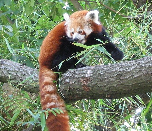 Rød panda
-
 Brunstrubet solfugl (Anthreptes malacensis).
-

-

-

Comments
-
-
Beautiful place, highly recommend this place for trekking
2 years ago -
A National park in Nepal in the lap of Makalu Peak. Many visitors from national and international, go for treaking upto Makalu Base Camp. It takes 6-7 days to reach there(Makalu Base Camp). Way is rocky and step. Nice view of hamalayas, flora and funna.
a year ago -
Treking in height attitude... Wildlife animals..plant,beautyful veiw of himalayan..save diffrent rare animal of himalayan wildlife Vist Nepal 2020
a year ago -
-
Didnot enter the park, only till the outskirts to see the Arun hydropower project. Good to spend 15/20 mins there and see the Arun river. No bathrooms or eateries around. To enter the tunnel, early morning trip advised as work begins at 8. If u reach before 8, can walk the tunnels
2 years ago -
Went from gola to hatiya one day trek cardamom trek wide beautiful landscape and the trail with the sound of arun river following each footsteps was worth the pain for the trip abd the people there were too good
3 years ago -