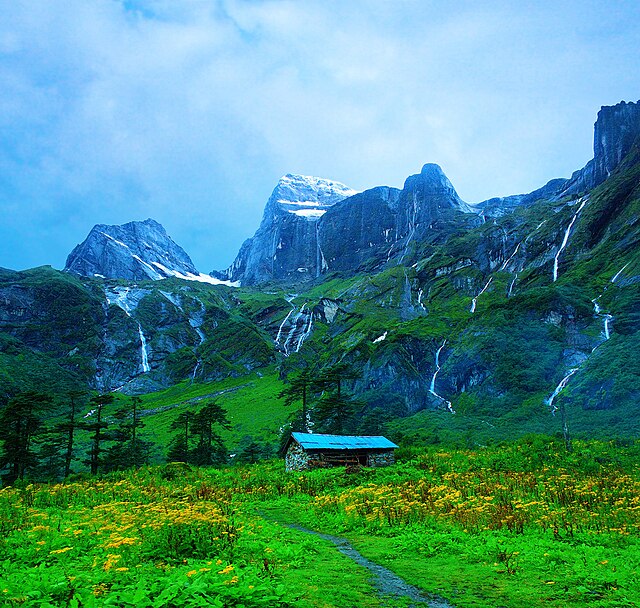


Parque nacional de Makalu Barun (मकालु-बरूण राष्ट्रिय निकुञ्ज)
El Parque nacional de Makalu Barun (en nepalí: मकालु-बरूण राष्ट्रिय निकुञ्ज) es el octavo parque nacional en el Himalaya de Nepal,[1][2] fue establecido en 1992 como una extensión oriental del Parque nacional de Sagarmatha. Con una superficie de 1500 kilómetros cuadrados de los distritos de Solukhumbu y Sankhuwasabha, es la única área en el mundo protegida con un desnivel de más de 8000 metros que abarca tanto bosques tropicales como picos nevados.
La frontera norte del parque nacional coincide con la frontera internacional de China en la región autónoma del Tíbet. Adyacente a la parte sur y la frontera sureste está la zona de amortiguamiento llamada área de conservación de Makalu Barun con una superficie de 830 kilómetros cuadrados.
Links
Images Gallery
Comments
-
-
Beautiful place, highly recommend this place for trekking
2 years ago -
A National park in Nepal in the lap of Makalu Peak. Many visitors from national and international, go for treaking upto Makalu Base Camp. It takes 6-7 days to reach there(Makalu Base Camp). Way is rocky and step. Nice view of hamalayas, flora and funna.
a year ago -
Treking in height attitude... Wildlife animals..plant,beautyful veiw of himalayan..save diffrent rare animal of himalayan wildlife Vist Nepal 2020
a year ago -
-
Didnot enter the park, only till the outskirts to see the Arun hydropower project. Good to spend 15/20 mins there and see the Arun river. No bathrooms or eateries around. To enter the tunnel, early morning trip advised as work begins at 8. If u reach before 8, can walk the tunnels
2 years ago -
Went from gola to hatiya one day trek cardamom trek wide beautiful landscape and the trail with the sound of arun river following each footsteps was worth the pain for the trip abd the people there were too good
3 years ago -